
"Bomb Cyclone" Hits Aleutian Islands, Setting Record for N. Pacific
On New Year's Eve, the far western reaches of the Aleutian Islands were rocked by the most powerful storm ever recorded in the North Pacific, with windspeeds equivalent to a Category 1 hurricane.
Two days in advance, the National Weather Service issued a warning for all waters between Atka to Adak for waves of 40-50 feet, hurricane-force winds and gusts up to 85 miles per hour. As the storm passed over, an ocean buoy at Amchitka Island recorded significant wave heights exceeding 58 feet.
The New Years Eve storm passed directly over Shemya, a U.S. Air Force island base located some 700 nautical miles to the west of Dutch Harbor. The weather station at Shemya recorded a low pressure of 924.8 millibars, setting a new record low for sea level pressure in the state of Alaska. The previous record was set in Unalaska in 1977 when a ship recorded a low of 925 millibars.
A new Alaska land-based low pressure record has been set! Shemya, AK dropped to 924.8mb at 2159Z (1259 AKST) today. The previous accepted record was from a ship in Dutch Harbor at 925mb in 1977. Pressure is now slowly rising at Shemya. #akwx #hurricaneforce pic.twitter.com/1yiYOPvsTr
— NWS Anchorage (@NWSAnchorage) December 31, 2020
The NWS Ocean Prediction Center surface analysis has a 921mb (27.20") low effectively on top of Attu, the westernmost Aleutian Island. That makes this the deepest cyclone near Alaska (evidently) since at least 1950. #akwx #BigStorm @Climatologist49 @DRmetwatch @capitalweather pic.twitter.com/8uGQshtOcT
— Rick Thoman (@AlaskaWx) December 31, 2020
Prelim highlights of #BigStorm New Year's Eve 2020:
— Rick Thoman (@AlaskaWx) January 2, 2021
• Min sea level pressure: 921mb, deepest storm near Alaska
• Shemya, Alaska: SLP 924.8mb at 22Z Dec 31 (Alaska's lowest)
• Buoy 46071 (south of Amchitka): sig wave height 58.1' (17.7m) at 01Z Jan 01 #akwx @Climatologist49 pic.twitter.com/8CFpWc2EEL
Here is the latest imagery of the #hurricaneforce low in the Pacific nearing the Bering Sea. Winds to 95 kts and wave heights over 50 ft are expected! pic.twitter.com/0lQs9l6Yl4
— NWS OPC (@NWSOPC) December 31, 2020
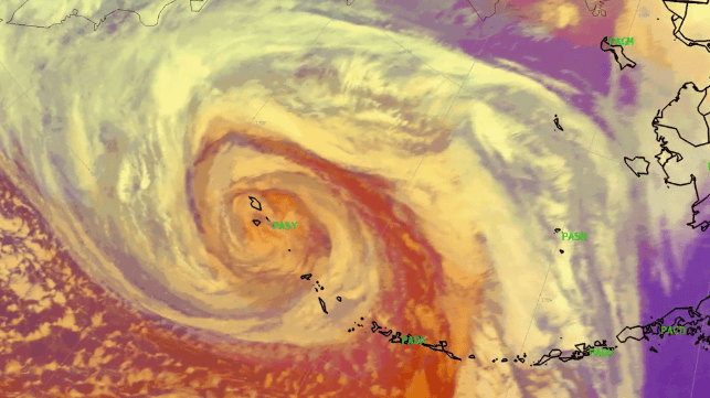
#GOES17/#GOESwest Air Mass RGB and Water Vapor images showed the Hurricane Force low approaching Alaska's western Aleutian Islands: https://t.co/8QnoPvKa7Z Winds at Shemya PASY gusted to 72 knots (83 mph) at 09 UTC. #AKwx pic.twitter.com/XTXBj2LQpW
— Scott Bachmeier (@CIMSS_Satellite) December 31, 2020

that matters most
Get the latest maritime news delivered to your inbox daily.
The storm occurred with a boost from the polar jet stream, the high altitude winds that transit the North Pacific in the mid-latitudes. The jet stream was forecast to hit 200 knots at the time the storm arrived in the Aleutians.
"Unlike hurricanes, [maritime cyclones] derive their energy from an entirely different process. While hurricanes extract heat from the ocean, maritime cyclones create energy by drawing together warm and cold air masses. When the warm air rises and cold air sinks, the kinetic energy of swirling wind is generated," said Capital Weather Gang's Jeff Halverson in a 2015 discussion. “The juxtaposition of warm and cold air is also what powers the polar jet stream - and indeed, maritime cyclones and the jet stream are inextricably linked - the one feeding back upon, and enhancing, the other."
