
Northeast and Canada Prepare for Hurricane Lee Causing Ships to Scramble
The Northeast coastline from Massachusetts to Maine, the Bay of Fundy region, and Maritime Canada are preparing for the arrival of Hurricane Lee which is also disrupting shipping as it begins its final northward charge before landfall which is expected late Saturday afternoon or evening in Canada. While the storm has begun to weaken and accelerate in speed, the National Hurricane Center of the National Oceanic and Atmosphere Administration is still warning of significant wave height, coastal flooding, storm surge, heavy rains, and now likely tropical storm force winds.
It has been many years since these areas have experienced a direct call with a hurricane raising additional concerns and warnings. In addition, the storm is heading into the area at the peak travel season when the region sees an increased number of tourists and cruise ship visits.
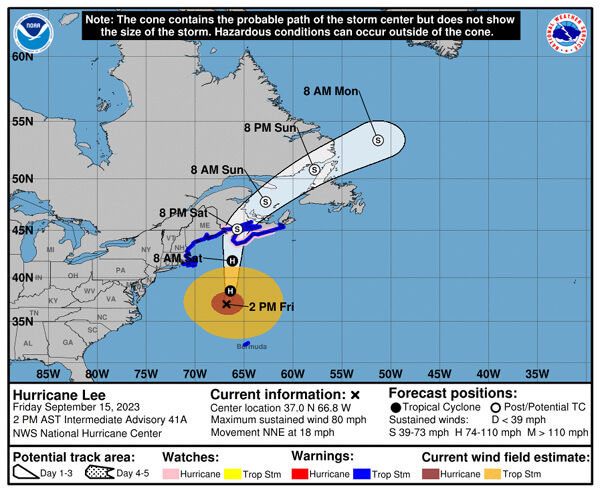
Forecast for Lee as it moves ashore likely falling from a hurricane to a topical storm (NOAA)
The latest forecast is showing the Lee has dropped to a category 1 storm with wind speeds of 70 to 80 mph down from 115 to 120 mph earlier in the week. In addition, the storm is now moving at a much faster pace of 18 mph in a north-northeast direction moving it further away from the U.S. coastline but still meaning it is likely to travel north through the Bay of Fundy and make landfall in New Brunswick or possibly move east into Nova Scotia as a topical storm with 65 mph winds later on Saturday. Large parts of the Maine coastline are expecting 50 mph winds, localized storm surge of 1 to 3 feet in susceptible areas, and 1 to 3 inches of rain.
The North Atlantic High Seas forecast however highlights the danger to shipping as the storm moves north today after brushing past Bermuda with high winds and rain. The Hurricane Center is warning shipping that in the NW quadrant, the seas are up to 45 feet and the calmest areas around the storm still have 12-foot seas. The wind cone extends 280 NM in an east semicircle and further in other quadrants. The storm is expected to fall to a post-tropical extratropical depression Sunday into Monday and finally dissipate within four days.
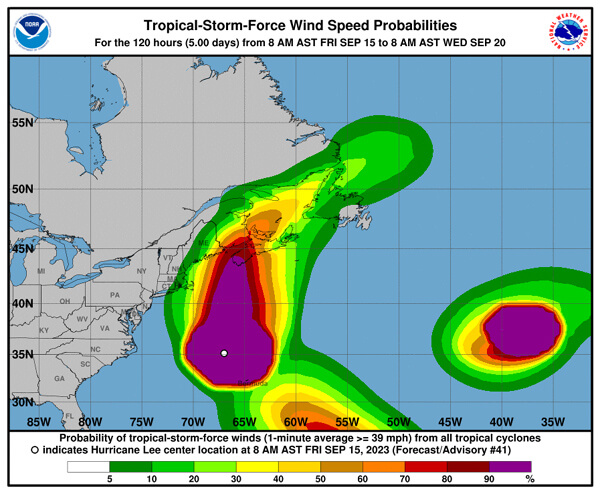
Lee's massive wind field is creating high seas and causing shipping to scramble to get out of the path of the storm (NOAA) (Note the second storm, Margot, in the mid-Atlantic further impacting shipping)
While residents along the coastlines are preparing for the ruff surf and storm surge, shipping has been scrambling to get out of the path of the storm. This has created some unusual events, especially with the high number of cruise ships operating at this time of the year in the New England – Canada region.
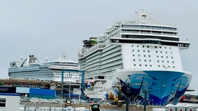
Wednesday saw the first three cruise ship day of the year for Saint John, New Brunswick, which rarely gets that many ships in a day. The Norwegian Escape (165,000 gt) and the Emerald Princess (113,500 gt) accelerated their calls into Canada to meet their requirement for a foreign port call before curtailing their itineraries and heading for safe haven ports. Oceania Cruises’ Vista (67,000 gt) also made the port call before the three ships headed to New York.
The Port of New York has maxed out its cruise docks, shuffling ships, and the last two to arrive have gone into the anchorage. In addition to the Vista, the Silver Shadow (28,250 gt) is at the Manhattan piers, and Royal Caribbean which normally docks in New Jersey shifted the Jewel of the Seas (90,000 gt) to Manhattan to make space at its primary pier which is now occupied with the Liberty of the Seas (156,000 gt). The Emerald Princess went to the Brooklyn Cruise Terminal while the Norwegian Escape and Seven Seas Mariner (48,000 gt) are in the Stapleton Anchorage off Staten Island.

that matters most
Get the latest maritime news delivered to your inbox daily.
There is a similar seen at Boston’s Black Falcon Terminal where the Caribbean Princess (113,000 gt), Norwegian Pearl (93,500 gt) and now P&O’s Aurora (76,150 gt) are taking refuge. Other cruise ships that had been scheduled to sail into the region, including Oceania Cruises' Insignia (30,000 gt) and Royal Caribbean’s Vision of the Seas (78,500 gt) instead diverted with substitute cruises to the Bahamas.
Other cruise ships have amended their itineraries in Canada or are steering out to sea away from the storm. The cruise lines will assess the damage to the ports from the storm but expect to be able to resume their itineraries by the end of the weekend.