
UK Hydrographic Office Supports Trade and Economic Growth in Belize
[By: UK Hydrographic Office]
The UK Hydrographic Office (UKHO) has started surveying the seabed of the southern waters of Belize as part of the UK Government’s Commonwealth Marine Economies (CME) Programme.
Almost all activity in our oceans, from shipping to monitoring delicate marine environments, depends on accurate seabed mapping data that illustrates the shape and movement of natural underwater features. For coastal nations like Belize, the collection of this data is vital to supporting sustainable economic growth and protecting communities from the effects of climate change.
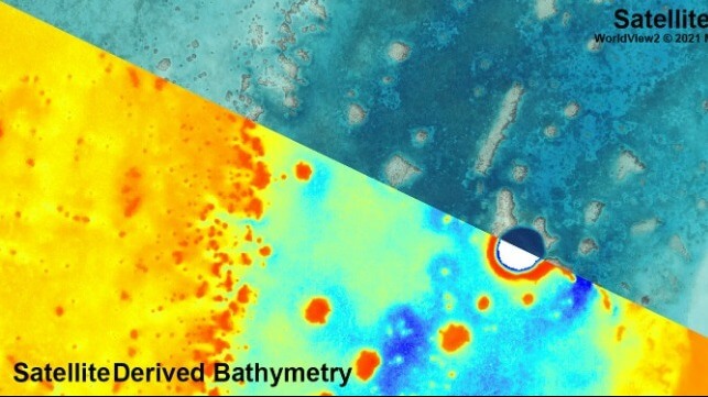
Following a stakeholder meeting with the Belize Port Authority and wider Belizean government in late 2019, it was agreed that the country’s southern waters would be surveyed using Satellite Derived Bathymetry (SDB). SDB uses satellites to capture high resolution imagery which can then be processed to calculate seabed depths down to 40 metres, depending on the clarity of the water. This method captures large areas quickly and has no negative impact on ecosystems and marine life. Data collection and processing is expected to take several weeks and will focus on areas south of Belize City.
Information from the survey will be used to update nautical charts of the region where necessary, reducing navigational risk and improving safety of life at sea. The SDB-generated information can also be used to plan and prioritise more detailed surveys of Belizean waters to support government requirements.
The data from the survey will be supplied to the Belizean government and can underpin a range of environmental and scientific applications, including improved management of coastal protection initiatives and the country’s rich marine environment. This includes the sustainable management of fisheries and other marine resources.
Ian Davies, International Hydrographic Portfolio Manager at UKHO, said:
“The new data being collected using funding from the Commonwealth Marine Economies Programme will help Belize to develop and manage its coastal waters, unlocking benefits for the nation for many years to come. The data gathered from this SDB survey will not only be utilised to check for dangers to navigation, but will also support other disciplines such as fisheries and coastal zone management, environmental planning, and maritime security. Equally importantly, it will also assist in the continued development of policies that protect the country’s marine environment and the sustainable use of Belize’s natural resources”.
The products and services herein described in this press release are not endorsed by The Maritime Executive.