
The Coast Survey's Role in the Hurricane Delta Response
NOAA’s Office of Coast Survey has concluded its hydrographic survey response following Hurricane Delta. At the immediate request of the U.S. Army Corps of Engineers (USACE), NOAA’s navigation response teams (NRTs) and NOAA Ship Thomas Jefferson surveyed areas within the Gulf Intracoastal Waterway (GIWW), Calcasieu Ship Channel, and the entrance to the channel. With lessons learned from the response to Hurricane Laura — the first major hurricane of the 2020 season and the first hurricane response during a pandemic — the teams and Thomas Jefferson successfully collected, processed, and delivered data to the USACE, identifying significant hazards to navigation and helping to ensure the timely reopening of waterways.
Delta made landfall along Louisiana’s coast as a Category 2 storm on Friday, October 9. By the afternoon of October 10, the NRTs were on the water, surveying many of the same areas they surveyed following Hurricane Laura including Devil’s Elbow, GIWW from the West Lock Gate of Calcasieu Lock to the toe of the Devil’ Elbow Reach, GIWW from intersection of Calcasieu River to LA 27 Bridge, and a portion of the Calcasieu River. They even had the opportunity to check in on National Ocean Service assets such as water level stations and tide gages.

Mission complete with merely 12 hours on the water. NRT-Stennis and NRT-Fernandina Beach vessels tied up at the Marine Spill Response Corporation (MSRC) facilities each evening after completing data acquisition (NOAA)
Coast Survey had a different strategy to collect and process data this time around in order to keep safe social distancing from one another and follow protocols with regard to the COVID-19 pandemic. Coast Survey established separate data acquisition and processing teams along with a data runner in between. This allowed for a quicker turnaround between data collection and processing to report results to the USACE for reopening the channel.
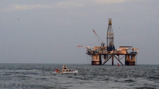
NOAA Ship Thomas Jefferson arrived on the scene after breaking with their Flower Garden Banks National Marine Sanctuary survey on the evening of October 11. The ship surveyed the complete Bar Channel from mile 0 to -32.5. Most, if not all Aids to Navigation were off station and the presence of a floating oil rig aground in the channel made the response particularly difficult. Thomas Jefferson found a sunken barge that stood approximately three meters off the seafloor. The least depth above the barge was nine meters in a 12 meter channel. Thomas Jefferson compared data NOAA collected from the Hurricane Laura response and verified that the barge was a new wreck.
NOAA Ship Thomas Jefferson Launch 2904 surveying the Bar Channel, Calcasieu, Louisiana Approach.

Chartlet identifying the location of the sunken barge delivered to the U.S. Army Corps of Engineers. Not for navigation.
Diverting a large hydrographic vessel from its planned project schedule to emergency work is a heavy logistical lift. Even under the best circumstances, last-minute changes to port call locations and timing affect crew rotation plans, critical food and supply deliveries, and maintenance planning. However, because of the COVID risk mitigation protocols, including shelter-in-place requirements and COVID testing phases, planning an urgent and safe response to Hurricane Delta was especially challenging and required close coordination among Coast Survey, the ship, Marine Operations Center – Atlantic, and NOAA’s Office of Marine and Aviation Operations.
This article appears courtesy of NOAA and may be found in its original form here.
The opinions expressed herein are the author's and not necessarily those of The Maritime Executive.