
Russia Gathers More Data for its North Pole Bid
A Russian expedition has gathered more data for substantiating the nation’s claim for more of the Arctic seabed.
The claim was lodged with the UN Commission on the Limits of the Continental Shelf (CLCS) in 2016 and includes 1.2 million square kilometers of territory. The Commission is expected to consider the claim in February.
Deputy Prime Minister Yuri Borisov said that the Russian Ministry of Defense conducted additional bathymetric and gravimetric studies, as well as acoustic profiling, during the recent voyage and therefore clarified critical points to justify the boundaries of Russian territorial waters. “I believe that these studies will be sufficient to exhaustively substantiate our application,” Borisov said.
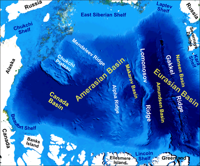
Russia claims areas beyond the 200-mile exclusive economic zone that cover the shelf of the Russian Arctic marginal seas, part of the Eurasian Basin (the Nansen, Amundsen basins and the Gakkel Ridge), and the Central Amerasian Basin, which includes the Makarov Basin and the Central Arctic Submarine Elevations. The nation claims that research has shown that the main parts of the Central Amerasian Basin are of continental origin and belong to submarine elevations that are natural components of the continental margin. In particular, Russia believes the data proves the continental origin of the Lomonosov Ridge, the Mendeleyev-Alpha Rise, the Chukchi Plateau and the fact that they are extensions of the shallow-water Eurasian shelf.
According to UNCLOS, a nation can claim an exclusive economic zone over the continental shelf abutting its shores. This would mean in Russia’s case that the seabed under the geographic North Pole would be subject to its oversight for mining and drilling.

that matters most
Get the latest maritime news delivered to your inbox daily.
Earlier this year, Canada joined Russia and Denmark in making a claim, based on the extent of its continental shelf, that includes the North Pole.
Russia says its most recent expedition also determined the maximum depth of the Barents Sea: 632 meters. For the first time in history, routing measurements were carried out along the entire length of the Northeast Vostochny and Neymera straits, as well as in the northern part of the Buta Strait between Greeley Island and Ugolnye Kopi Island. Additionally, new islands were recorded including five islands in Vise Bay on the North Island of Novaya Zemlya.