
Ocean Currents: A Powerful Ally or Enemy?
By Mike O'Brien, Senior Operations Manager, Applied Weather Technology
Ocean currents can make or break the economies of an ocean passage. As the leader in fleet optimization services, AWT is still haunted, in some respects, by the term “weather routing.” The services we provide have long since evolved beyond the optimal weather route for a particular passage. Even so, the term “weather routing” itself is especially one-dimensional to accurately describe the detail and work that goes into “optimizing” a route.
Besides maximum wind, sea and swell conditions, AWT also examines speed, fuel consumptions inside of ECA/SECA zones, non-ECA steaming speeds and a variety of other constraints that are acceptable given the load condition of the vessel.
Today, however, the focus of this article is on a force that is significant in helping ships travel along or slowing their progress:ocean currents. These rivers of water in the oceans are among the most important factors to consider when optimizing a route. The influence of ocean currents will vary considerably based on several factors, but most importantly the speed and heading of the ship.
A ship moving at 20 knots through a 200NM area of adverse ocean currents will have a shorter duration of exposure to this area compared with a 13-knot vessel. In this route example, a tanker on a voyage from Panama to the Philippines was ordered to steam at approximately 14 knots. AWT initially suggested a route that sailed WSW from Panama to 02-00N 095-00W then Rhumb Line 02-00N 150-00W, then WNW toward the Philippines in order to take full advantage of favorable west setting ocean currents north of the equator.
The image below shows the east/central Pacific portion of the voyage. The color scheme represents the velocity of the ocean currents, and the yellow and orange colors indicate stronger west setting ocean currents that were at times up to 2.7 knots.
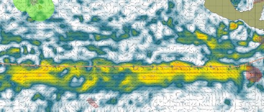
Looking at the route you can see how AWT took advantage of these ocean currents in its route recommendation. Additional benefits of sailing at that latitude included passing south of the strongest E-NE  conditions prevailing south of the east/central Pacific ridge of high pressure, as well as passing south of heavy northwestern swells moving into the tropics of the Pacific from the mid-latitudes.
The challenge of this route, however, was the distance. If the addition of distance is too great, the benefits of the west setting ocean currents will be negated and perhaps entirely eliminated.
This route was compared with the next best option, which AWT calculated to be a Great Circle south of the Hawaii ECA zone, then Rhumb Line approaches to the San Bernardino Strait. Sailing such a route saved a substantial 270NM over the route AWT suggested to the Master. Despite this addition of distance, however, the strong west setting ocean currents, limited E-NE wind and seas, and reduced exposure to northwest swells, made this recommendation the optimal route. By utilizing AWT’s suggested route along 02-00N, the tanker was able to confirm an earlier arrival date.
By taking advantage of the positive ocean currents, the data from the voyage shows real, substantiated benefits, and not just a theoretical advantage. The image below shows that prior to entering the favorable ocean currents, the vessel was only making speed over ground of 13.5 knots. Upon entering the strong west setting ocean currents, the speed increased and was as high as 15.10 knots and frequently above 14.6 knots while sailing along 02-00N.
Conclusion
Despite a recent decline in the price of fuel oil, the level of scrutiny on all environmental factors that go into voyage optimization remain critical. The influence of ocean currents cannot be underestimated as the above route spotlight demonstrates. Advances in our ability to see the core of strong ocean currents using Hybrid Coastal Model (HYCOM) ocean current data has allowed AWT to make enormous leaps forward compared to decisions based on older pilot chart data.
When optimizing your fleet’s performance, AWT utilizes the latest data sources, technology and proprietary software to realize savings on a wide range of speed, fuel and environmental factors not the least of which are ocean currents.