
China Adds Another Dash to the Map
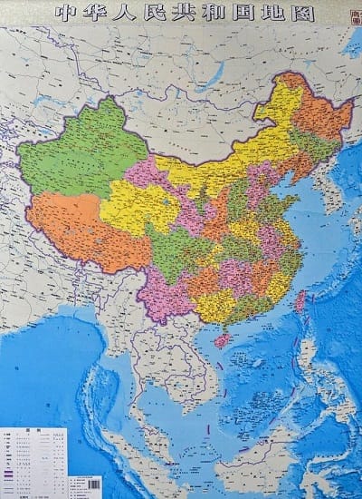
A local publishing house in China has published a vertical map of the country giving equal weight to land and sea areas. The new map is different because traditional horizontal maps show the islands in the South China Sea in a cut-away boxes in the bottom corner. The idea is to strengthen the country’s territorial claims, and the map now has 10 rather than nine dashed lines marked in the South China Sea.
 Neither Vietnam nor the Philippines are impressed.
However, local Chinese media say the map helps to promote awareness and highlight its historic title over the South China Sea. Thus it is a legitimate move. China is a party to the UNCLOS and has been adhering to its principles, reports say, and there is no conflict in China abiding by the UNCLOS and substantiating its sovereign claim over the islands and the adjacent waters by high-lighting its historic title. After all, reference to historic titles is part of the UNCLOS.
Historic title generally signifies the rights a state has had over certain waters for a considerable time, either sovereign rights or otherwise, for example traditional fishing rights. From the perspective of the UNCLOS, historic title is considered an exception to the applicability of the provisions on sea boundary delimitations. According to Article 15 provisions on the delimitation of the territorial sea between states with opposite or adjacent coasts do not apply “where it is necessary by reason of historic title or other special circumstances”. Article 47 says, “if a part of the archipelagic waters of an archipelagic state lies between two parts of an immediately adjacent neighboring state, existing rights and all other legitimate interests which the latter state has traditionally exercised in such waters” shall continue and be respected.
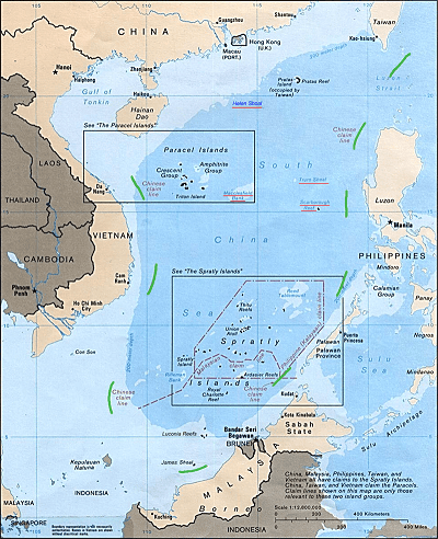 China has a long history of exploring and exploiting the South China Sea and, hence, has historic title over the sea, which is proven by the nine-dash U-shaped line marked on official maps since the 1940s. Although China's Exclusive Economic Zone and Continental Shelf Act says conflicting claims on the exclusive economic zone and the continental shelf by China and countries with opposite or adjacent coasts shall be settled on the basis of international law, it clarifies that “the provisions of this act shall not affect the historical rights of the People's Republic of China”.
Le Hai Binh, spokesperson for Vietnam’s Foreign Affairs Ministry, said Thursday that China’s new self-prescribed map covers almost the entire East Sea, including Vietnamese islands. “We have, many times, reaffirmed Vietnam’s position on the Hoang Sa (Paracel) and Truong Sa (Spratly) islands. We strongly condemn the wrongful acts of China and request it to respect international laws and the Declaration on the Conduct of Parties in the South China Sea (DOC),” Binh told a press briefing on Thursday.

that matters most
Get the latest maritime news delivered to your inbox daily.
Picture credit new map: Hurun Map Express, Xinhua
