
Due to COVID-19, Drone Survey Powers NOAA's Bering Cod Assessment
Every other year, NOAA Fisheries conducts an acoustic-trawl survey from crewed research vessels to measure pollock abundance in Alaska’s eastern Bering Sea. As a result of COVID-19, many research surveys were canceled, and we weren’t able to conduct our walleye pollock surveys. Data collected from these surveys are critical to manage pollock, which comprise the nation’s largest commercial fishery.
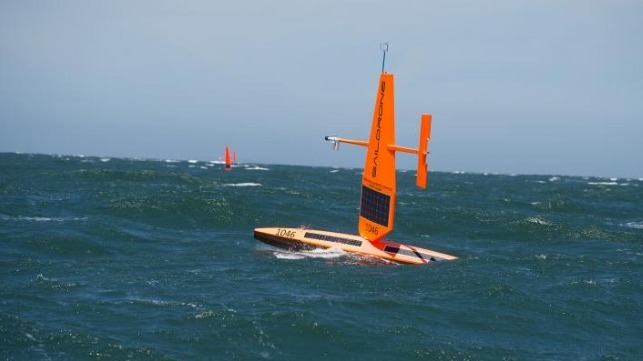
NOAA Fisheries scientist Alex De Robertis at the Alaska Fisheries Science Center developed a contingency plan: conducting the survey with saildrone wind- and solar-powered ocean-going robots. The hope was to collect some data despite the vessel survey cancellation.
For the past several years, De Robertis and colleagues at the Alaska Fisheries Science Center have been working with partners at NOAA Research’s Pacific Marine Environmental Laboratory, Saildrone and Kongsberg. They use uncrewed surface vehicles equipped with low-power sonar (acoustic) sensors to conduct research in the Bering and Chukchi Seas. The pollock survey contingency plan was an opportunity to apply what they had learned to collect data for resource management.
“We were impressed with how well the saildrones performed. This was particularly helpful in a year when there are no other sources of survey information for pollock,” said De Robertis. “From a technical standpoint things went as well as one could have hoped. The saildrones and the acoustic equipment we use to count fish performed flawlessly while at sea for five months.”

Vehicles at Saildrone headquarters in Alameda, California. Credit: Saildrone.
Three saildrones were used to conduct the survey. They left California in mid-May and sailed 2,200 nautical miles to the Bering Sea. From July 4 to August 20, the saildrones were able to survey the area typically covered by the standard research vessel. They collected information to estimate pollock abundance and oceanographic and atmospheric information for weather forecasting.
After the survey ended, the saildrones sailed back to Alameda, California—Saildrone Inc. headquarters. Under a time crunch, data were downloaded and sent to De Robertis and other NOAA Fisheries scientists for processing and analysis as soon as the vehicles arrived.

Survey track for the saildrone fleet in the Bering Sea. Other lines mark sail to and from Alameda, California. Figure: NOAA Fisheries.
“We received the data in mid-October. We only had four weeks to analyze them and determine whether they could be incorporated into the stock assessments used to estimate pollock abundance in this area of the Bering Sea,” said De Robertis.
The analysis was needed in time to inform scientific discussions that occur with the North Pacific FIsheries Management Council every year in mid-November. This is when annual assessments of commercial fish stock abundance and trends (whether abundance is going up or down) in the Bering Sea, Aleutian Islands, and Gulf of Alaska are completed. Resource managers rely on these assessments to develop fishery management measures for the upcoming fishing year.

Example of a 100-minute backscatter record from the 2020 saildrone survey. Pollock aggregations are abundant at > 40 m. Credit: NOAA Fisheries.
For De Robertis and his colleagues, the goal was to be able to use data collected by uncrewed surface vehicles for the first time in the pollock assessment. They were successful. Scientists were able to derive an estimate of abundance for midwater pollock based on the observations made by the saildrones.
The total biomass (weight) of midwater pollock was 3.6 million metric tons. Overall, it indicated that pollock populations declined by roughly 14 percent from 2019 to 2020.
Overcoming Data Limitations
Scientists processed the data using the same methods used for conventional acoustic data collected on ship-based research surveys. However, they also had to contend with a few challenges specific to the saildrone data.
Due to the COVID-19 pandemic, it took longer to get the saildrones there and back because they had to sail to Alaska from California rather than being shipped to the study area. This meant that scientists had to modify survey plans because they had less time to complete the survey. Rather than surveying transect lines 20 nautical miles apart, the saildrones surveyed transects that were roughly 40 nautical miles apart. As a result, there was less sampling effort.
During ship-based pollock surveys, trawl samples are used to verify the species, age and size of fish in the catch. This information, which is used to convert acoustic signals to fish abundance (biomass at age or size), cannot be gathered using uncrewed surface vehicles. With less reliable and detailed information to work with, scientists had to account for greater uncertainty in the data.
![]()
The three saildrones (plotted in different colors) split up and each surveyed a sector of the Eastern Bering Sea along transects with a 40 nm spacing, as opposed to Dyson’s typical 20 nm spacing. Credit: NOAA Fisheries.
Scientists used models to estimate the additional uncertainty due to the reduced amount of sampling. They developed methods and used biological data collected in past surveys to convert the observed backscatter to pollock biomass.
“It was great to be able to put what we have developed to practical use in a very challenging situation. We were able to achieve our goal to provide some survey estimates of pollock abundance in the Bering Sea this year to support resource management decisions,” said De Robertis.
While not a substitute for the full spectrum of tasks that crewed research vessel surveys can undertake, the technology proved to be highly effective in an unusual year. This is an area that is developing rapidly. Going forward, ocean-going robots with scientific sensors like the ones used in this study are likely to be used more broadly.
This article appears courtesy of NOAA Fisheries and is reproduced here in an abbreviated form. It may be found in its original form here.
The opinions expressed herein are the author's and not necessarily those of The Maritime Executive.