
Robots to the Rescue
Autonomous vessels are unlocking the secrets of the ocean.
(Article originally published in July/Aug 2021 edition.)
It's January 2019, and despite it being the middle of the summer in the Southern Hemisphere, Antarctica's freezing winds are blowing 80 mph and producing 50-foot waves.
The world's first wind- and solar-powered autonomous sailing vessel, the 23-foot Saildrone Explorer, endured the extreme weather while surviving collisions with giant icebergs on its 196-day, 12,000-nautical-mile mission to circumnavigate Antarctica. It deployed a total of four drones on a scientific mission to survey krill abundance, track tagged penguins and seals, and measure the rate of CO2 absorption in the Southern Ocean for the National Oceanic & Atmospheric Administration (NOAA) and NASA.
Over the past decade, autonomous unmanned or uncrewed surface vessels (USV) and autonomous underwater vehicles (AUV) went from a novel concept to a booming maritime industry subsector. From autonomously navigating without direct intervention from humans, uncrewed systems are helping us better understand "Spaceship Earth's" natural environment through objective, peer-reviewed and verifiable data.
As part of the United Nations Sustainable Development Goals 2030, the U.N. Decade of Ocean Science seeks to stimulate exploration and knowledge-generation to reverse the decline of the ocean marine ecosystem. One stated goal is the General Bathymetric Chart of the Oceans (GEBCO) Seabed 2030 Project, which hopes to map the remaining 80 percent of the uncharted ocean floor by 2030.
According to the Organization for Economic Cooperation and Development (OECD), the so-called "Blue Economy," including the preservation and regeneration of the marine environment, is worth $1.5 trillion per year and provides more than 31 million full-time jobs. We caught up with three of the foremost USV manufacturers to learn more about the state of the art.
The Little Saildrone That Could
Backed by Google, California-based Saildrone is looking to build an armada of 1,000 solar- and wind-powered USVs, each covering a six-by-six-degree area (one Saildrone per 360 nautical square miles) for in-situ observation of the world's oceans in near-real-time.
This quiet USV company has racked up an impressive portfolio of over 10,000 days at sea and traversed 500,000 nautical miles while collecting hundreds of millions of data points. They have active partnerships with NOAA's Pacific Marine Environmental Laboratory, Atlantic Oceanographic and Meteorological Laboratory and Schmidt Ocean Institute, to name a few.
Saildrone's Founder & CEO, Richard Jenkins, developed the wing technology during his 10-year effort to break the land speed record for wind-powered vehicles, which he did in 2009 at a speed of 126.2 mph. Jenkins now operates a fleet of carbon-neutral Saildrones to harness ocean and wind data for what he calls "The Quantified Planet."
"We’ve more completely mapped the surface of Mars than our own earth's ocean floor,” he says. “However, with only 20 percent mapped, it will take centuries – and fortunes – to complete using legacy methods." With crewed survey vessels costing $35,000 to $75,000 per day to operate compared to approximately $2,500 per day for Saildrones, its mission-as-a-service offers year-round, cost-effective data collection at scale for up to 365 days of ocean data, ocean mapping and maritime domain awareness.
Saildrone currently maintains three platforms, the 23-foot Explorer, 34-foot Voyager and the 72-foot Surveyor, each one designed for specific missions, water depths and sensor suites. They also come in your favorite color, so long as it's international orange.
Saildrone's Vice President of Ocean Data, Andy Ziegwied, a seasoned applied oceanographer, says that sensor fusion on its various platforms provides seafloor classification and high-resolution feature mapping with near-shore and open-ocean bathymetry (down to 7,000 meters below the surface) with incredible accuracy. These USVs provide solutions for nautical chart validation, meta-ocean data collection (atmospheric measurements, sea surface temperature, air-sea fluxes and carbon absorption) for improved climate models, and ecosystem monitoring of fisheries and salinity.
The new 72-foot Surveyor is being deployed to remote and harsh environments such as Arctic regions and hurricane zones where moored instruments and free-floating platforms get easily ejected or destroyed. There are five Saildrones deploying this Atlantic hurricane season to quantify the variability of surface fluxes (rate of change of heat, carbon and moisture) over annual cycles in the Gulf Stream.
Such missions will help better understand the carbon cycle budget used for forecasting global climate transformation. Along with its massive storms, the Gulf Stream feeds off heat energy while also pumping CO2 into the ocean at relatively high rates.
Asked if any alarming data had been captured over time, Jenkins cited the 1-2 parts per million (ppm) increase in CO2 each year in the Arctic. "When we started measurements in 2016, it was 402 ppm. It’s now 418 ppm, which is a very significant rate of change in temperature and CO2." He adds that "Data quality relies on lots of testing and verification. Real accuracy is tough to achieve. Sensors need to maintain accuracy, and the data is heavily scrutinized through peer-review."
Kongsberg
Norway's Kongsberg has been manufacturing sensors, USVs and AUVs since 1993. Its solutions for oceanographic sensors and marine survey platforms for research and mapping are a staple in the industry.
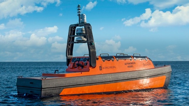
Atle Gran, Area Sales Manager for Marine Robotics, says Kongsberg’s 26-foot Sounder USV was designed as a multipurpose sonar and hydro-acoustic application for seabed mapping and fish finding/research. Equipped with the K-MATE autonomy controller, Sunstone Navigation System and Maritime Broadband Radio/Iridium VSAT, the shipping container portable USV can rapidly deploy anywhere in the world and survey for 20 days while transmitting near-real-time data. The flat-bottom hull and moonpool configuration allow for custom sensor suites.
Peru's TASA, the world's largest producer and exporter of fishmeal and fish oil, is in a partnership to deploy the Sounder USV for persistent monitoring of resources for fish detection, classification and tracking.
Mayflower Autonomous Ship (MAS)
During its June attempt at becoming the largest autonomous vessel to cross the Atlantic, the Mayflower Autonomous Ship (MAS) had to pause its mission to resolve a "small mechanical issue." The 49-foot, fully-autonomous, AI and solar-powered research trimaran was three days and 250 nautical miles into its planned 21-day, 3,800-nautical-mile voyage when the exhaust gas coupling from one of the generators failed.
As a result, the intelligent system returned home, parked 100 miles offshore and went into loiter mode while waiting for recovery. The MAS Project is a collaboration between IBM, industry, academia and ProMare, a U.S. nonprofit research organization.
"Luckily, MAS wasn't lonely, bored, injured or scared,” says Brett Phaneuf, Founding Board Member of ProMare. “If a person were on that vessel and couldn't fix it, there would have been an emergency."
He then revealed that the brunt of the work has been structuring the software and validating it. "The boat part was easy, but our biggest concern was a mechanical failure. You can only design out and make so many things redundant" – a keen observation given that the replacement part for the motor is nine months out.
Phaneuf explains how much they underestimated the resistance to autonomous vessels: "The reality is that no one has rules for this. The U.S. and U.K. took different stances. The U.K. Coast Guard had trouble with classification and wanted to register it as a workboat while the U.S. Coast Guard was remarkably forward-leaning, and we ended up registering it as a pleasure craft."
Other regulatory hurdles involved explaining how unmanned systems do not have an onboard crew to prevent a collision, which IBM's AI Captain currently performs. Phaneuf's reply is, "Well, it's okay for a single-crewed sailboat to sleep at night. Worst case, the intelligent system will send a notification to someone onshore to help remotely navigate via an end-to-end, real-time encrypted Iridium VSAT uplink. The voyage itself was extremely boring because we didn't get near anything."
The closest point of approach to another vessel was one nautical mile of a 15-meter sailboat. "No news is good news,” says Phaneuf. “We aim for boring. We’re more convinced that the real danger of collision is within 12 miles of shore, at which point we’ll take an escort vessel."
The MAS Project will use the time to upgrade systems, as computing power has quadrupled since last year’s install, and perform more sea trails. Once underway again, the public can remotely monitor the ship's systems and progress through the online portal at www.mas400.com.
Preserving Spaceship Earth
As the industry moves toward the broader adoption of these platforms, exponential amounts of data are being amassed. The above examples demonstrate the immense capabilities autonomous unmanned systems offer to better understand, quantify and manage our natural environment. Hopefully, their integration will help us preserve Spaceship Earth for future generations. – MarEx
Sean Holt is a regular contributor to The Maritime Executive and serves on the Board of Directors of AUVSI (Autonomous Unmanned Vehicle Systems International) - Cascade Chapter.
The opinions expressed herein are the author's and not necessarily those of The Maritime Executive.