
The Six Ingredients for Hurricane Formation
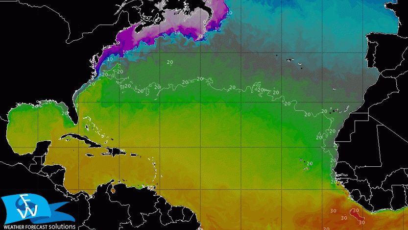
As we approach the 2017 Atlantic Hurricane Season (June 1 to November 30), observing the sea surface temperatures [SST] indicates the “hot spots” – no pun intended – for hurricane development/intensification.
The term “hurricane” is synonymous with cyclone and typhoon, with the only difference being where they are geographically located: Hurricanes refer to tropical cyclones located in the Atlantic and Eastern Pacific Ocean, typhoons are tropical cyclones located in the Central and Western Pacific waters. In the Indian and South Pacific Ocean basins, they go by their general name, cyclones.
While SST values are one of the important determining factors to observe, cyclogenesis (the birth of a cyclone) requires a specific set of conditions to be in place in order for actual development/intensification to occur. Let’s dissect these six major ingredients to fully understand the complexity of one of nature’s most powerful systems.
1. Sea surface temperatures [SST]: Minimum SST of about 80°F is necessary to provide enough heat content to “fuel” the system. This temperature needs to be distributed through at least 160 feet (50m) in ocean depth. According to Richard A. Dare and John L. McBride of the Centre for Australian Weather and Climate Research, 98 percent of global cyclone formation occurs when SST values exceed about 78°F. So while meteorologists may watch thunderstorms pumping off the African Coast in anticipation of cyclone development, until there is sufficient water temperatures to fuel future development, the thunderstorm moves offshore and remains just a thunderstorm out to sea.
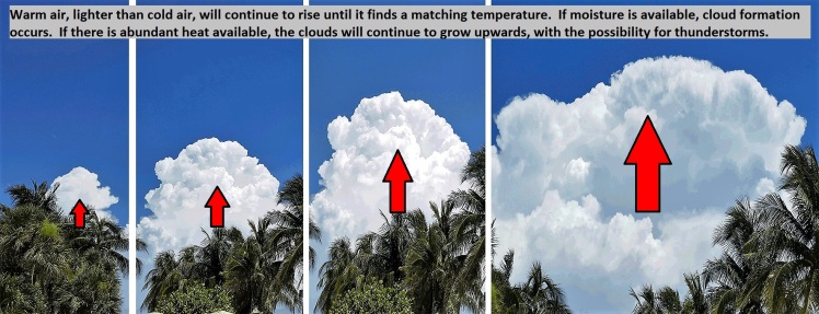
2. Unstable Atmosphere/Vertical Motion: An unstable atmosphere is defined by one in which warm air continues to rise until it finds itself surrounding by air of an identical temperature. Once it finds its “home base”, this is what is known as equilibrium. So what causes this warm air to rise? The answer lies within the density differences between warm and cold air.
Imagine you were in a 10’ x 10’ room in the middle of a Siberian winter, with no heat. You would want to fill this room with as many people as possible to keep warm, stuffing person after person into the space to capitalize on the generated body heat. Now imagine the same 10’ x 10’ room is located in the middle of hot Texas summer day with no A/C available; you would want to kick many of these people out of this room, to keep as much distance between yourself and any other heat generating individuals. Now exchange people for molecules: more people (molecules) in the room (air) makes the room weigh more, less people (molecules) in the same room (air) make the room weigh less. While the volume of the room stays the same, the amount of molecules (people) is what differs. And there you have it, cold air is denser than warm air, therefore explaining why the warm air continues to rise until it achieves equilibrium.
Provided there is adequate moisture present in the atmosphere, this rising warm air and moisture combine work in tandem to develop clouds. If the rising motion continues unchecked, this will allow the clouds to continue building vertically, which brings the potential for thunderstorms.
3. Relative Humidity [RH]: Relative humidity is the amount of moisture available in the atmosphere, compared to how much it could fully hold (100 percent humidity). High values of RH need to be present from the lower to middle portions of the atmosphere. So how much is enough? Low values of RH cannot support cloud/thunderstorm development, and the 50 percent threshold of RH is borderline at best, whereas 70 percent and above is considered prime RH territory.
4. Preexisting condition: It may begin as a simple thunderstorm, but some form of a disturbance or an area of lower pressure relative to its surroundings is the bullet to the trigger. If a disturbance has any chance of developing into something more, it must develop or migrate into a region of the above mentioned factors.
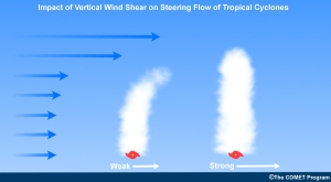 5. Wind Shear: Wind shear is defined as the change in wind speed/direction with height. These changes in wind direction with height must be enough to sustain a counterclockwise flow [low pressure’s spin counterclockwise in the Northern Hemisphere], but not too strong or it may move the heat and moisture away from the center of the system.
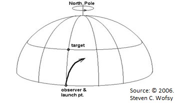 6. Coriolis Force: This is important. This force, as a result of the earth’s rotation, induces motion to the right in the Northern Hemisphere and to the left in the Southern Hemisphere. Think of launching missiles: you don’t aim at the target, but slightly off, to compensate for the earth’s rotation (below).
 In addition, the amount of Coriolis force increases as the distance from the equator increases. The sweet spot for adequate force is about 300 miles from the equator, although formation outside of that is entirely possible. It is physically difficult for formation to occur within five degrees of the equator, because the amount of Coriolis force is simply too weak. Consequently, once a system rises above 20 degrees latitude, the other above-mentioned conditions become harder to maintain/achieve, so the ideal “Goldilocks Zone” for cyclogenesis remains between five and twenty degrees.
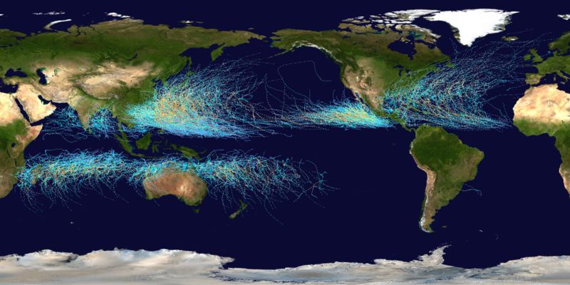
Global tropical cyclone tracks between 1985-2005. Photo courtesy of Nasa.gov
So while the Atlantic Basin hurricane season is generally characterized by the June 1 – November 30 time frame, if the above conditions are met outside of that time frame, hurricane formation/intensification is entirely possible. Of all the Atlantic storms on record, 97 percent have formed within the above mentioned time frame, but what about the other three percent? The earliest known system has been re-analyzed to have occurred in January (1938) and the latest development has occurred in December (1954), towards the end of the month. So while unlikely, it’s both historically and statistically conceivable.
Given the position of the earth and the amount of incoming solar radiation, ocean basins may indeed reach the required temperatures to support a breeding ground. If all other conditions are met, a hurricane (or typhoon or cyclone) is on the way.
This article appears courtesy of the Weather Forecast Solutions blog and has been edited for length. It may be found in its original form here.
The opinions expressed herein are the author's and not necessarily those of The Maritime Executive.